 Neuerscheinungen 2012Stand: 2020-01-07 |
Schnellsuche
ISBN/Stichwort/Autor
|
Herderstraße 10
10625 Berlin
Tel.: 030 315 714 16
Fax 030 315 714 14
info@buchspektrum.de |
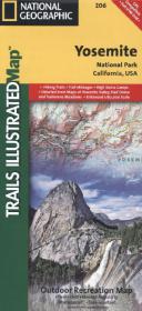
National Geographic Trails Illustrated Map Yosemite National Park, California, USA
Outdoor Recreation Map. Hiking Trails, Trail Mileages, High Sierra Camps, Detailed Inset Maps of Yosemite Valley, Half Dome and Tuolumne Meadows. GPS Compatibles. Full UTM Grid. Waterproof. Tear-resistan
Rev. 2012. 1 S. 965 x 660 mm
Verlag/Jahr: NATIONAL GEOGRAPHIC MAPS 2012
ISBN: 1-56695-299-9 (1566952999)
Neue ISBN: 978-1-56695-299-6 (9781566952996)
Preis und Lieferzeit: Bitte klicken
Yosemite Nationalpark inkl. Stanislaus National Forest, Emigrant Wilderness, Carson Iceberg Wilderness, Toiyabe National Forest, Hoover Wilderness, Inyo National Forst, Yosemite Wilderness, Sierra National Forest, Ansel Adams Wilderness
Trails Illustrated topographic maps are the most detailed and up-to-date recreation maps available for these national parks, national forests and popular outdoor recreation areas. Coverage in this map includes: Stanislaus National Forest, Toiyabe National Forest, Inyo National Forest, Sierra National Forest Emigrant Wilderness, Carson Iceberg Wilderness, Hoover Wilderness, Yosemite Wilderness, and Ansel Adams Wilderness with detail on Yosemite Valley and Tuolumne Meadows. Also provides UTM grids for use with your GPS unit.