 Neuerscheinungen 2012Stand: 2020-01-07 |
Schnellsuche
ISBN/Stichwort/Autor
|
Herderstraße 10
10625 Berlin
Tel.: 030 315 714 16
Fax 030 315 714 14
info@buchspektrum.de |
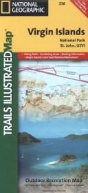
National Geographic Trails Illustrated Map Virgin Islands National Park, St. John, USVI
Outdoor Recreation Map. 1 : 22.000
2012. 1 S. 965 x 660 mm
Verlag/Jahr: NATIONAL GEOGRAPHIC MAPS 2012
ISBN: 1-56695-346-4 (1566953464)
Neue ISBN: 978-1-56695-346-7 (9781566953467)
Preis und Lieferzeit: Bitte klicken
Virgin Islands Nationalpark inkl. St. John, Virgin Islands National Park in its entirety, Virgin Islands Coral Reef National Monument, Mount Sage national Park, Tortola Island, Great Thatch Island, Little Thatch Island, Frenchmans Cay, End, Lovango Cay, Congo Cay, Mingo Cay, Dog Island, Hawksnest Bay, Durloe Cays, Durloe Channel, Cinnamon Bay
Trails Illustrated topographic maps are the most detailed and up-to-date recreation maps available for these national parks, national forests and popular outdoor recreation areas. This map includes: the island of St. John; the entire Virgin Islands National Park; Virgin Islands Coral Reef National Monument; Mount Sage National Park; Tortola Island; Great Thatch Island; Little Thatch Island; Frenchmans Cay; Lovango Cay; Congo Cay; Mingo Cay; Dog Island; Hawksnest Bay; Durloe Cays; Durloe Channel; Cinnamon Bay; Trunk Bay; Mary Point; Francis Bay; and UTM grids for GPS.