 Neuerscheinungen 2012Stand: 2020-01-07 |
Schnellsuche
ISBN/Stichwort/Autor
|
Herderstraße 10
10625 Berlin
Tel.: 030 315 714 16
Fax 030 315 714 14
info@buchspektrum.de |
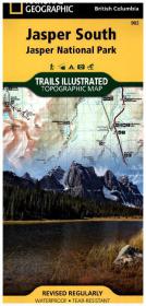
National Geographic Trails Illustrated Topographic Map Jasper South
Jasper National Park. Alberta, British Columbia. Waterproof, tear-resistant. 1 : 100.000
Rev. 2012. 1 S. 965 x 660 mm
Verlag/Jahr: NATIONAL GEOGRAPHIC MAPS 2012
ISBN: 1-56695-660-9 (1566956609)
Neue ISBN: 978-1-56695-660-4 (9781566956604)
Preis und Lieferzeit: Bitte klicken
Karte, beidseitig bedruckt, wasserfest
The front side of the Jasper South map details the east side of the national park, from Whitehorse Wildland Provincial Park to the north, to White Goat Wilderness Area to the south. The reverse side of the map details the west side of the park, extending from Cummins Lakes Provincial Park to the south, to Victoria Cross Ranges to the North. Insets show survival tips, safe travel in Bear Country, and all the recreation the park has to offer with backpacking, camping, biking, hiking and horseback riding. This map is printed on waterproof, tear-resistant material.