 Neuerscheinungen 2012Stand: 2020-01-07 |
Schnellsuche
ISBN/Stichwort/Autor
|
Herderstraße 10
10625 Berlin
Tel.: 030 315 714 16
Fax 030 315 714 14
info@buchspektrum.de |
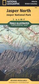
National Geographic Trails Illustrated Map Jasper North
Jasper National Park. Waterproof. Tear-resistant. 1 : 100.000
Rev. 2012. 1 S. 965 x 660 mm
Verlag/Jahr: NATIONAL GEOGRAPHIC MAPS 2012
ISBN: 1-56695-661-7 (1566956617)
Neue ISBN: 978-1-56695-661-1 (9781566956611)
Preis und Lieferzeit: Bitte klicken
Karte, beidseitig bedruckt, wasserfest
The front side of Jasper North map details the east side of the national park, from Rock Lake Solomon Creek Wildland Park to the north, to Whistler´s Summit to the south. The reverse side of the map details the west side of the park, extending from Mt. Terry Fox Provincial Park to the south, to Willmore Wilderness Park to the North. Insets show survival tips, safe travel in Bear Country, and what to do while visiting. A necessity for exploring in the outdoors, this map is printed on waterproof, tear-resistant material.