 Neuerscheinungen 2019Stand: 2020-02-01 |
Schnellsuche
ISBN/Stichwort/Autor
|
Herderstraße 10
10625 Berlin
Tel.: 030 315 714 16
Fax 030 315 714 14
info@buchspektrum.de |
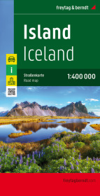
Freytag & Berndt Autokarte Island; Ijsland; Iceland; Islande; Islanda
Cityplan, Ortsregister, Entfernungen in km. 1 : 400.000
2019. Aufl. 2019. 25.5 cm
Verlag/Jahr: FREYTAG-BERNDT U. ARTARIA 2019
ISBN: 3-7079-0451-2 (3707904512) / 3-85084-570-2 (3850845702)
Neue ISBN: 978-3-7079-0451-2 (9783707904512) / 978-3-85084-570-0 (9783850845700)
Preis und Lieferzeit: Bitte klicken
Neben der übersichtlichen Gestaltung bietet die Straßenkarte Island 1:400.000 zahlreiche Zusatzinformationen wie z.B. Straßenbeschaffenheit, Sehenswürdigkeiten, Campingplätze und einen Innenstadtplan. Mit dem umfangreichen Ortsregister gelingt zudem eine rasche Orientierung.
Details: Cityplan Reykjavík, Ortsregister mit Postleitzahlen, Entfernungen in km.
freytag & berndt Autokarten sind für viele Länder und Regionen weltweit erhältlich.
A two sided detailed road and tourist map of Iceland at a scale of 1:400,000 (1" to 6 miles). The map is on one side and the index is on the reverse. Shading is used to accent the land in relief. Selected elevations and distances are shown. Contour lines are superimposed at 200 meter intervals. There are insets of central Reykjavik at a scale of 1:5,000 (13" to a mile). A locator map shows Iceland in relation to Europe, and some photographs of the scenery. In addition to road classifications and fuel stations, the extensive legend includes geysirs, caves, waterfalls, national parks, hiking shelters, and golf courses. The legend is in Danish, German, English and Italian.